Projects
Melba Property
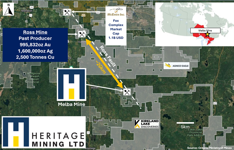
The Melba Mine is located in Northeastern Ontario, Canada Southeast of Matheson Ontario (Figure One) approximately seven kilometers east off the Highway 11, on the section of highway travelling from Kirkland Lake to Cochrane. The Melba Mine is located in northeastern Ontario close to the Ontario and Quebec border. It’s fortunate the location of the Melba Property lies within the central hub of over 100 years of mining activities, including active mining operations within the Abitibi Greenstone Belt. The claim package includes single cell mining claims covering 1,522.70 hectares and one mining lease.
Property Geology
The governing element of structure appears to be a contact between dioritic greenstone to the south and argillaceous greywacke to the north. The contact trends north 50-60 degrees west and dips northward. Whether the greywacke is part of a synclinal trough of sediments that are younger than the greenstone or whether it is part of a sedimentary band belonging to the greenstone series is an unknown factor at present. The greywacke is cut by dikes of porphyry that run parallel to the contact. The main gold bearing vein, usually described as the “Blue Vein”, also runs parallel to the contact but lies within the sediments. It strikes north 55 degrees west and dips northward 55 degrees. It is accompanied by shearing and alteration, also by a pattern of cross fracturing that has produced faulting in the main vein and has led to the development of irregular veins in the adjacent rocks. The main vein is displaced 60 feet (18.2 metres) northward near the shaft and other displacements have been found underground. The geological setting resembles that of the sedimentary belt in the Beatty-Munro area. Numerous feldspar porphyry, diorite and basic syenite dikes were intersected by the drilling. Overall, a significant amount of the drill core showed alteration, some highly, while carbonate stringers were numerous and visible gold was noted in drill core.